









Meta Description:
GTA 6 mapping project update reveals new Leonida locations, airports, islands, military bases and map details ahead of the next major reveal.
Summary:
The latest GTA 6 mapping project adds more detail to Leonida, connecting trailer footage, screenshots and real-world Florida locations while separating confirmed information from speculation.
GTA 6 Guide: A Complete Breakdown of the Latest Leonida Map
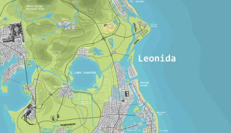
The latest GTA 6 community mapping project has received a major update, giving players a clearer picture of Leonida and its surrounding locations. By combining trailer footage, screenshots, leaks and real-world geography, the community has mapped everything from Vice City and Star Island to airports, islands and rural areas. For players following GTA VI, the biggest takeaway is simple: the map is becoming increasingly detailed, but plenty remains unconfirmed. Players planning their future in-game economy can also check options to buy GTA 6 Money.
GTA 6 Map Guide: What the Community Has Mapped
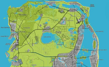
The updated project separates information into several categories, which is important when judging how reliable individual locations are.
| Map Detail | Status |
| Roads and railways | Confirmed/speculative |
| Trailer locations | Confirmed |
| Vice City areas | Partially confirmed |
| Islands and coastal areas | Mixed |
| Military locations | Speculative/partially supported |
| Leak-based locations | Based on previous material |
| Northern map expansion | Unconfirmed |
One of the most useful features is the ability to zoom into individual areas and connect screenshots with their suspected locations. This allows players to compare environmental details, roads, bridges and buildings with footage already released by Rockstar.
Tip: Treat the map as a research project rather than an official Rockstar map. A marked location does not automatically mean its exact position has been confirmed.
Mount Cale and Northern Leonida
The northern section could become one of the most interesting parts of GTA VI. The mapping project connects mountain scenery, winding roads, forests and possible railway routes with locations inspired by Florida geography.
Mount Cale National Park is particularly notable. Trailer and promotional imagery suggests a large natural environment featuring mountains, wildlife, forests and waterways.
Other suspected northern locations include Lake Leonida, Ambrosia and Port Gellhorn. The project also identifies possible airports and other infrastructure, although several of these placements remain speculative.
GTA VI Map Guide: Vice City, Islands and Airports
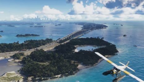
The Vice City region is considerably easier to analyze because Rockstar has already shown substantial footage. The latest mapping update adds more detail around waterfront areas, docks and roads visible in promotional material.
Several recognizable Florida-inspired locations also appear across the project.
Locations Worth Watching
Star Island: Connected to imagery featuring luxury homes and coastal environments.
Fisher Island: A likely inspiration for another wealthy island community.
Peanut Island: Positioned farther north within the mapped region.
Key West: Expected to provide another distinctive island environment.
Boca Chica Key: Associated with a suspected military or Air Force facility.
Kennedy Space Center: A possible northern landmark based on real-world geography.
Port Gellhorn International Airport: Another suspected airport within Leonida.
The airports could become particularly important because the map appears to contain multiple aviation hubs rather than relying exclusively on Vice City International Airport.
Another interesting update concerns the waterfront section of Vice City. New mapping work connects a promotional image showing boats and buildings with a specific area, giving players a more precise idea of how Rockstar's city layout may fit together.
Confirmed vs. Speculation
The biggest challenge with the GTA 6 mapping project is separating evidence from educated guesses.
Confirmed screenshots provide the strongest foundation, while locations derived from real-world comparisons should be treated as predictions. Some areas also rely on older leaked material, meaning their presence may be supported by previous information but their exact placement can still change.
Quick checklist for reading the map:
Check whether the location comes directly from official footage.
Compare recognizable buildings, roads and terrain.
Look for multiple screenshots supporting the same position.
Treat real-world Florida comparisons as evidence, not confirmation.
Expect the map to change when Rockstar releases new footage.
What the Updated GTA 6 Map Means for Players
The project suggests that Leonida could offer significantly more environmental variety than simply a larger Vice City. Players may move between dense urban areas, luxury islands, rural towns, mountains, wetlands, military facilities and long stretches of coastline.
That variety could also have a major impact on exploration and future gameplay systems. Different terrain types may naturally support different activities, vehicles and missions.
For players following GTA VI, the next major official reveal should provide the best opportunity to test these community theories against new footage. Until then, the mapping project remains one of the most useful ways to organize scattered clues.
Final verdict:
The updated map is impressive, but players should distinguish confirmed locations from speculation. The real value is how quickly the community can connect small pieces of official footage into a much larger picture. Players interested in preparing their future GTA economy can also buy GTA VI Money.
TL;DR
The latest GTA 6 mapping project significantly expands the community's understanding of Leonida, covering Vice City, islands, airports, rural regions and possible military locations. Much of the project is evidence-based, but several placements remain speculative.
Which mapped location are you most excited to explore when GTA 6 finally launches?